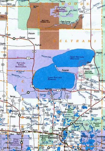
Where is Saum & Shotley?? And directions to Carsella's Access!
Where is Saum?? Where is Shotley??
Directions to Carsella Access (Back roads /Shortest Routes)
FROM BLACKDUCK----Take Hwy. 72 north 9.7 miles to Busy Corners intersection. From Busy Corners intersection go straight ahead/north on County Rd. 36--3.9miles to County Rd. 34. Take a left and head west on County 34--5.8 miles. When you come to stop sign, turn right on to County Rd. 23. Go north on County 23--8 miles to stop sign. Turn left on Shotley Rd. N.E. (County Rd. 108). Go west 0.9 miles to Sandberg Rd. and take a right. Access will be on left hand side at the end of Sandberg Rd. Saum is on County Rd 23 or Pioneer Rd NE as it is called now. The store is on the left as you go north towards Upper Red Lake.
FROM NORTHOME----Take Hwy. 46 through Northome. Turn left in Hwy. 71 and head west--3 miles to Hwy. 1. Take Hwy. 1--9.7 miles to Busy Corners intersection. Take a right at Busy Corners intersection on to County Rd. 36. Go north on County 36--3.9 miles to County Rd. 34. Take a left and head west on County 34--5.8 miles to stop sign. Turn right at stop sign on to County Rd. 23 and go north--8 miles to Shotley Rd. N.E (County Rd. 108). Turn left on Shotley Rd. N.E. and head west--0.9 miles to Sandberg Rd. Turn right on Sandberg Rd. Access will be on left hand side at the end of Sandberg Rd. Saum is on County Rd 23 or Pioneer Rd NE as it is called now. The store is on the left as you go north towards Upper Red Lake.
FROM BEMIDJI AND SOUTH---As you are going north from Bemidji on State Hwy 71 take a left in Turtle River on County Rd 23 (just past the liquor store on your right). Follow County Rd 23 all the way to Saum and north. The road curves around Gull Lake and you need to watch for signs where you will turn left and then straight north. When you come to State Hwy 1 you will take a right and then a left onto 23 again after about a mile. That road will be gravel. It is the way we prefer to take to Bemidji since it is shorter. There are jogs and turns at the correction lines of the township. You can always call for directions. GPS systems are not always reliable on these back roads it seems!! Just stay with Beltrami County Road 23 and you won't have a problem!! (Psalm 23---Saum 23  )
)
Take 72 North through Kelliher. Dr. Tackle in Kelliher is a good place to get bait. Stay on 72 North out of Kelliher & go 9.6 miles to County Rd. 23 (Artesian Spring Rd.). Turn left on county 23 and go 8.2 miles to Shotley Road (Church on SW corner). Turn right on to Shotley Road and go 3 miles to Sandberg Road. Turn right on to Sandberg Road. Go to end of Sandberg Road and access is on left hand side.
Below is a generalized map of the area. Carsella's Access is a little west, almost to the Red Lake Reservation Line. And below the map you can find the DNR's GPS coordinates for the boundry line!
Upper Red Lake (Beltrami County): State Anglers Legal Fishing Boundary
Boundary Information
When fishing near the Red Lake reservation boundary, using a GPS unit will ensure compliance.
Those portions of Red Lake located within the Red Lake Indian Reservation are closed to non-band members except by special authorization of the tribal council.
State anglers: The actual boundary is not a true north-south line. To simplify, it is recommended that State anglers stay east of the longitudinal coordinate of 94° 43' 12.0" W to ensure they are on State waters.
Everyone fishing near the boundary is responsible for knowing his/her location!
